SOLUTION -- Simple Python command line enumeration of ESRI Shapefile DBF attributes -- reporting column name, column length and data type -- the DBF "schema" -- inside a "naked" Win32 command line environment. Suitable for Cut-n-Paste reporting and analysis.
APPROACH -- Python Script -- heavily modified from ESRI web site hints and kinks -- listed below.
# =====================================================================
#
# Abstract: Script to Enumerate ESRI Shapefile Attributes
# for Analysis and Reporting
#
# Revised: 2010-11-18 -- New create from ESRI web hints
# and examples
#
# Version: Update for ArcGIS 10.x and ArcPY
# "GeoProcessing" imports
#
# Contact: R.Marten
# Q7 GeoComputing
# 24165 IH-10 West #217
# SATX 78257
# Email: Q7GeoComputing_at_WarpMail_dot_Net
#
# From:
# http://help.arcgis.com/en/arcgisdesktop/10.0/help/index.html#\
# //000v0000001p000000
#
# =====================================================================
#
#
# import arcgisscripting, os, sys # -- ArcGIS 9.x imports
# gp = arcgisscripting.create(9.3) # -- ArcGIS 9.x instantiation
import arcpy, sys, os # -- ArcGIS 10.x imports
# For each field in the feature class (shapefile or GDB),
# print the field name, type, and length.
#
# ----- GDB data store Approach ----
# fieldList = arcpy.ListFields("C:/Data/Municipal.gdb/Hospitals")
#
# ----- Shapefile data store Approach ----
# fieldList = arcpy.ListFields("c:\gis\usgs\usgs_tx_24k_centroids_wgs84.shp")
# --- Check the number of command line arguments.
if len(sys.argv) == 1:
print "Script requires a file argument -- feature class (Shp or GDB) "
print "Try Local Dir: %s my_file.shp" % ( sys.argv[0] )
print "Try Full Path: %s c:\gis\usgs\usgs_tx_24k_centroids_wgs84.shp " % ( sys.argv[0] )
else:
shp_file = sys.argv[1]
# fieldList = gp.ListFields( shp_file ) # --- version 9.x and earlier
fieldList = arcpy.ListFields( shp_file )
print "Field Name Len Name "
print "========== === ==============================="
for field in fieldList:
print("{0:10} {1:3} {2:8}"
.format(field.name, field.length, field.type ))
# === end script ===
USE & PROCEDURE STEPS -- Rough invocation steps are:
(1) Cut and paste the above script into a simple ASCII text file -- and save in a "safe" and easy to find folder location. Suggest "c:\Downloads\ArcPY_Examples"
(2) On a WinXP or Win7 platform -- with ArcGIS 10.x installed -- create a "safe" working folder -- something like "c:\Downloads\ArcPY_Examples." This maybe accomplished from the GUI / Windows "explorer" -- or via command line thus -- with typed commands in bold:
c:\where_ever_cmd_starts> mkdir c:\Downloads
c:\where_ever_cmd_starts> mkdir c:\Downloads\ArcPY_Examples
(3) Open a Win32 command window -- and type the following commands:
c:\where_ever_cmd_starts> cd c:\Downloads\ArcPY_Examples
c:\Downloads\ArcPY_Examples>
z_Enum_Shp_Fields_v10.py Parcels_20130730_nad27.shp
RESULTS #1 -- Screen capture of command line invocation of above script --- and targeting an example suite of tax parcels:

click for larger view
RESULTS #2 -- Screen capture of command line invocation and script results -- note the bracketed output:
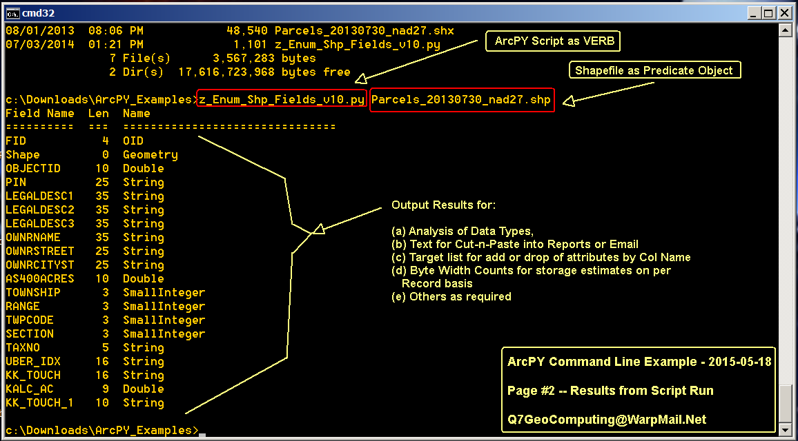
click for larger view
CHALLENGES and POTENTIAL FRICTION POINTS --
(a) The 1st time this script is invoked -- especially on a freshly booted machine -- the ArcGIS Python modules and libraries will not be "memory resident" -- or fresh in the disk drive buffer queue -- and script startup may require 20 secs to 2 mins -- time depends upon many system factors. After 1st invocation -- the script will execute promptly for any other shapefile -- as the necessary Python modules and libraries will be "handy" to the Operating System.
(b) ArcGIS License? Got one? If the ArcGIS installation is "boot-legged" -- the script may fail to start -- as the import of the ArcPY modules also performs a valid license check.
OTHER EXAMPLES -- The above is just one, simple, low-impact example using ArcPY at the "raw" command line -- and extract the DBF "database" schema. Other examples developed in the past -- ideas to add to problem solving toolbox:
(a) Generating regular measurement and field sample grids via ArcGIS FISHNET -- useful for GPS and seismic field layouts and cross measurement checks. Many oil & gas seismic layouts maybe generated -- or "re-created" and/or "repaired" from design parameters via ArcGIS FISHNET.

Typical Seismic Design
Parameters
(b) Exporting shapefile "layers" based upon some categorical attribute data in a DBF table. -- many AutoCAD folks will struggle to understand shapefile categorization via DBF attributes -- and will ask for a shapefile "layer" that has "only the NO ENERGY" -- or "only the NO MULCH" -- or "only the NO FLY" -- or whatever. When there are more than 3-5 attribute categories -- a script is a more SURE FIRE (deterministic) and REPEATABLE method of exporting each category value as a shapefile layer.

Categorical Map vs Legend "Layers"
(c) Generation of XY "shotgun scatter" pseudo-random points for low-bias statistical sampling and "attribute pulls." Basically setting up a map -- with randomly scattered XY locations -- to "pickup" a third / fourth / fifth / etc attribute -- Z1 / Z2 / Z3 / etc -- and perform some summary stats for "hot spots" and "heat maps" and "peaks & pits" identificaton.

XY Scatter Search for Peaks & Pits
SUMMARY -- Sometimes there is no replacement for a deterministic, repeatable and document-able script to capture some key workflow in data mining.
No comments:
Post a Comment